A Tour of JSA/Panmunjom

Thursday, September 20, 2012


The afternoon would be the JSA/Panmunjom tour.  At Imjingak, those who would be going on this tour were called and asked to transfer to a different bus.  This time, each person is assigned a seat number.

Our first stop is lunch.  It's a bulgogi lunch near the area.  It's my first time to try this and I love it.  The area has long tables with "burners" that could be shared by 2 people.  It includes rice, beef, lettuce and different kinds of banchan (side dish).  Water is free but if you want soda, those are included in the meal, you will have to pay for it.  Banchan is unlimited.  One can get whichever one wants from the area near the counter.  The meal was more than enough for 2 persons... at least for my Mom and I.

Bulgogi Lunch
Bulgogi Lunch
After lunch, we continued with the tour.  Our first stop is at a security gate.  I believe this is a gate to be able to go inside the Southern Boundary Line of the DMZ.  A number of vehicles, and tour buses are lined up here.  We were advised to take out our passport and open it to the identification page for security purposes.  Once at the gate, the bus turned back and got back on the line.  Not sure why but it might have something to do with the papers.  The second time around, we were let in.  A soldier went up the bus checking at the identification papers.  Before proceeding, we were reminded that taking of pictures are not allowed either inside or outside the bus, except when notified. 


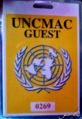
UNCMAC Guest Badge
Badge given to us which we should wear all the time
We passed by an actual village (Daeseong-dong/Freedom Village), the only one inside the DMZ in the South Korean side.  Here are some information I got from our tour guide:
  • Residents here, we were told, are mostly engaged in farming.  
  • Nightly curfew is in effect.
  • Loud sounds are not allowed.  
  • They have to live in their residence for a certain number of days in a year to maintain residency here.
  • Male villagers who marry a woman from outside the village can live with his wife in the village.  If I remember it right, women are not given the same privilege.
We've also passed by the area where we could see the flagpole in Kijong-dong (one of the tallest flagpole in the world), and it's South Korean counterpart in Daesong-dong closer.

We then came into Camp Bonifas and the JSA Visitor Centre.  It is only in front of the building where taking pictures are allowed.  The visitor's orientation is held here.  The half oval-shaped building on the left of the picture houses a souvenir shop.  Aside from souvenirs, there are also North Korean products available here.

JSA Visitor Center
JSA Visitor Center
From here, we transferred to a military-driven bus.  We also have a military escort on the bus as well.  We occupy the same seat numbers as the one we have on the original tour bus.  We have to wait a bit as only one tour group at a time is allowed to go to the Freedom House.  We passed by another gate (or was it two?) before we got to the Freedom House.  We're so near the Military Demarcation Line (MDL) now.   

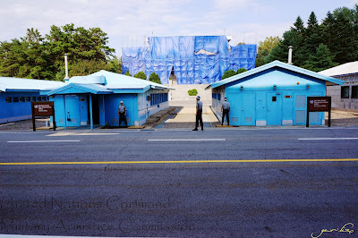
We disembarked from the bus and followed the lead of our tour guide inside the building and out on the other side where we could see the United Nations Command Military Armistice Commission (UNCMAC) buildings, the MDL and Panmun-gak (on the North Korea side). 

UNCMAC
United Nations Command Military Armistice
Commission (UNCMAC) Buildings

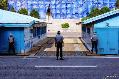
It's unfortunate that the Panmun-gak is under renovation at the time of our tour.  But did you notice that there are no visible soldiers on the other side?  As per our tour guide, there would only be soldiers standing on the North Korean side if they also have visitors.  However, there would always be soldiers on the lookout.


UNCMAC
UNCMAC Buildings
UNCMAC Conference Building
We entered into the UNCMAC Conference Building.  It is in this building where meetings between officials from the North and South Korea meet.  Only one tour group is allowed inside the building at a time.  Once all of us are inside, a soldier closes the door we used to enter.  There are 2 soldiers inside the building with us.  One of the soldiers guards the door to the North Korean side of Panmunjom.  He locks it and make sure nobody from NoKor will enter the building when tourists from SoKor are still inside.  This goes the same way for North Korean visitors.  The other soldier is literally in 2 places at one time.  He's got one foot in North Korea and another in South Korea. 

In the middle of the room, where one of the soldiers stood is the conference table being used by North and South Korea. The speakers in the center mark the MDL (Military Demarcation Line). So, technically, if the North and South Koreans meet, they're still in their country. 
Conference table
Conference table
Conference table
Soldier guarding the door to North Korea
The MDL is a really important landmark between the two Koreas but if you'll look at it, it's just a cement block (at least from what's visible to me) that marks the separation.  Looking out the window of the conference room, we saw that the South Korean side of the UNCMAC buildings have gravel, while that of the North Korean have sand.

MDL
Military Demarcation Line
We were supposed to pass by the area of the Bridge of No Return/Axe Murder Incident, however tour on that part of JSA has been stopped for the afternoon for security purposes.  Those who took the morning tour were lucky since the area hasn't been restricted before our tour group.

That's the end of our tour.  We were dropped off at the Lotte Hotel in Seoul (near City Hall).  We were assisted by one of the coordinators to the PTC office and paid our tour fee.  It was a long day, now it's time to take some rest and get ready for tomorrow.

Morning Tour at DMZ


We arrived Incheon Airport around 5AM via Korean Air.  Had some light breakfast before boarding the bus straight to Lotte Hotel in Seoul where we would be meeting with the DMZ tour coordinator.    
Sunrise view on the way to Seoul (from the airport)

Following the instructions in the email, we waited by the piano in the lobby.  The coordinator was a bit late, and since the office does not open until 9AM, we were told that we'll just pay after the tour.

Our first stop was Imjingak Park.  It's the closest place to DMZ without the special permits.  Here is where the tourists are registered by the tour coordinators.  The tourists are allowed 25-30 minutes to go around the area.  Sight-seeing in the area includes the War Memorial Altar, Freedom Bridge and Peace Bell.

Welcome to Imjingak
The Peace Bell
The Peace Bell

As we bid farewell to 20th century in which we witnessed the division of the Korean Peninsula, we welcome the 21st century as a time of reunification and peace of mankind. It is here, at the point that marks the division of North and South Korea that the hopes and prayers of 9 million Kyonggi citizens come together in the erection of the Peace Bell Monument. The Peace Bell which is 2.23m in diameter, 3.8m high and weighs 21 tons is made of bronze and tin in the traditional Korean style. 

The bell pavilion which is made of wood with a four-sided arched roof has an area of 70.5m2 and 12.18m high. 

January 1, 2000 
Lim, Chang-Yuel 
Governor of Kyonggi Province
War Memorial Altar

The Stones of Peace Wall 

This sculpture is made from stones collected from battlefields all over the world that have witnessed the suffering and grief of war. 

It is my sincere wish that the bringing together of these stones collected from 86 battlefields in 64 different countries will be a stepping stone for the reconciliation of the Korean People and mark the beginning of a century of peace and harmony for all mankind.

January 1, 2000
Lim, Chang-Yuel 
Governor of Kyonggi Province
The Stones of Peace Wall


Freedom Bridge

Freedom Bridge

Standing behind Mangbaedan Memorial Altar at Imjingak Square, Freedom Bridge takes its name from the return of 12,773 prisoners of war in 1953 in the first exchange of prisoners after signing the armistice agreement that ended the Korean War. 

Two railroad bridges on the Gyeonggui Line originally spanned the Imjingang River side-by-side. Both were destroyed by bombing; only the piers remained. To enable the exchange of prisoners of war, the west bridge was rebuilt as a temporary structure over the original piers. The repatriates were taken to Freedom Bridge by trucks, and crossed the bridge on foot. 

Freedom Bridge is 83 meters long, 4.5 meters wide, and 8 meters high. It is a wooden structure reinforced by steel. Freedom Bridge has little architectural value but holds tremendous symbolic importance of 'Return to Freedom.' 

 
According to the train operator at that time, the train was backed due to the intervention of the Chinese Communist Forces on the way to Pyeongyang to deliver war materials and it was finally destroyed at Jangdan Station. More than 1,020 bullet holes of the locomotive and its bent wheels show the cruel situation at that time.
Steam Locomotive at Jangdan Station of Gyeongui Line

Registered Cultural Heritage NO.78
Year of Manufacture: Unknown
Spec: Mountain Type, Effective Long-distance Freight Transportation
Max. Speed-80 km/h, Size-15m(L)x3.5m(W)x4m(H)

This steam locomotive is a symbol of tragic history of the division into North and South Korea, having been left in the DMZ since it got derailed by bombs during the Korean War.  After having been recognized its historical value and having become Registered Cultural Heritage in 2004, it is exhibited at the present location.


After that brief stop, we proceeded with the tour.  We went into the secured area of the DMZ.  I remember we passed by the South Korean gate to Kaesong (an industrial complex jointly run by the North and the South). In this zone, pictures are only allowed at designated areas.  If one gets caught, the tour for the group may be canceled or the camera will be confiscated (or will they just delete the picture... sorry, I forgot).  It was only when we disembarked the bus that we were allowed to take pictures.


The 3rd Tunnel
The South Korean Military was informed of the third tunnel by a North Korean defector, Kim Bu-Seong, who fled communist state on September 5, 1974.
He claimed to have measured the tunnel by looking at a large poplar tree in the Southern Demilitarized Zone from North Korean 212 GP.
One hundred seven PVC cylinder pipes of 7.5cm in diameter were then filled with water and installed every 2 meters along the expected invasion route to the south.
Three years later, on June 10, 1978, one of the cylinder pipes exploded with water shooting up into the air. Hence, five more cylinder pipes were quickly installed nearby, and South Korea was finally able to penetrate the tunnel that North Korea had intended for use in a military invasion.
From October 4, 2003 to June 19, 2004, the TBM machine bored a 358 meter long, 3 meter diameter tunnel at a gradient of 11 degrees. This tunnel was opened to the public for tours on June 30, 2004.
The third tunnel is arch shaped and 1,635 meters in total length. It lies 73 meters beneath the surface, and is 2 meters in height and 2 meters in width.
When this tunnel was discovered, it ran 1,200 meters up to the Military Demarcation Line and 435 meters into the south. Today, visitors can explore the tunnel up to 265 meters, at the end of which there is a third blockade.
Beyond the blockade, the tunnel leads through to the Military Demarcation Line.
There is evidence that this tunnel was intended for invasion of the south.
First, the tunnel is sloped approximately 3 degrees toward the north, which causes water to drain to the north.
Second, the dynamite holes, meant to explode the granite, face south.
Third, although coal was never found in this area, traces were left upon the rock wall to disguise the tunnel as an old coalmine.

Cameras (even bags) are not allowed inside the tunnel so I wasn't able to take any pictures.  They provide lockers in case you need to leave your things.  Since my mom would just be waiting for me at the lobby, I left my things with her.  Once inside, you have to wear a helmet as a safety precaution.  Just look for a size that fits you.

The tunnel experience.  The entrance to the tunnel is wide and downhill.  From the image above, I believe it's 358m long.  Once you get to the entrance, the path becomes narrow with only 2-3 persons that can fit side-by-side, the walls damped.  The farther I go, it becomes more uncomfortable and harder to breathe.  I think halfway to the 3rd blockade, I went back as I'm conscious of the time.  My biggest hurdle was the uphill walkway.  I was just glad that we still have about 30 minutes before we leave to explore the other building in the area.


Those in the lobby could see the inside of
the tunnel through the CCTV cameras installed
Back outside, since there's still time, we were able to have some more pictures taken, and visit the displays they have on the other building.


DMZ miniature on the glass floor
DMZ Miniature


Next stop is Dora Observatory, which is close to the Third Tunnel.  We got there around 10:30AM.  It is on top of Dora Mountain and is part of South Korea closest to the North.  A view of the North Korean village, Kijong-dong, can be seen using the telescopes in the viewing deck.  There's a yellow line in the viewing deck that designates up to which point are pictures allowed to be taken.


We just stayed there for about 10-15 minutes then we proceeded to our last destination for the tour... Dorasan Station.


Dorasan Station

Inside Dorasan Station (Platform)


Soldiers stationed at Dorasan Station
View of Dora Mountain (where Dora Observatory is)
from Dorasan Station

The tour ended back at Imjingak.